Lyonesse, Where the Sun Sets Last
- A Sea Kayakers Guide to the Isles of Scilly -
By Mark Rainsley
First published in 'Paddles' Magazine
Full Gallery of Scilly photos by Mark Rainsley
We're just coming up on Menawethan Island, the most easterly point of the Scillies. We're keeping our heads and paddles down as there's a stiff wind from the southwest, Force something or other. If I was a better person I would have managed to wake up for the 0555 Shipping Forecast. Or at least, maybe by nine. As it is, we've had to make do with the mumbled guesstimates from Radio Cornwall, far from reassuring…the other evening the weather presenter had fallen asleep on air. We're not worried though. There is a clear view down the Road, the wide channel between the largest of the Scillies. We can see right through to the outer reefs, sharp wedges of granite with whitewater exploding behind them. Beyond that is, well, Brazil. Quite a run-up for the waves. No worries though, the sea is calm inside the reefs and the worst of the wind is soaked up by the islands. On a day when she'd usually be firmly rooted on dry land, my wife is enjoying herself immensely. Her attention is completely absorbed by the surrounding scenery, rather than staying upright. Hailing from northern Scotland, she's entranced by the Hebridean quality of the small isles around us; even though a few miles away there are beaches which would be more at home in the Caribbean. We make out a shape balanced precariously on the rocks ahead, a large amorphous blob of plasticine. Getting closer, it turns out to be a particularly obese seal. Typically, he waits to within a split second of the camera being ready before he ripples his belly off the rock and disappears with an unceremonious snorting dive-bomb. As we round the cliffs of China Point, The noise is deafening as dozens of Black-backed gulls take to the air and screech the bird equivalent of, "Shove off". We have the sense of being followed, and look back over our shoulders. Sure enough, the seal is back, with his equally inquisitive mates. They follow us at a discreet distance, occasionally surfacing right beside us by accident. There is a split second where the seal's eyes meet those of the paddler, then a huge splash as he downs periscope fast.
An hour later we are real people again, wearing dry clothes, drinking beer and scoffing cake from the bakery on St. Martin's. The sun is now blazing and the kit is drying out nicely among the bright garish flowers of the Scillies.
How to use this guide: Take a marker pen and cross out anything which sounds like an opinion. You will be left with a small number of facts to work with, which are quite certainly possibly not inaccurate.
Why: The Scillies are stunning, a truly unique environment which is simply impossible to describe adequately. Partly a piece of England, partly a piece of the Atlantic; but much more than the sum of its parts. Although the area is small, the variety is great. Any kayaker who isn't captivated by this maritime paradise in miniature simply doesn't have a soul. Nice beer and cream teas, too.
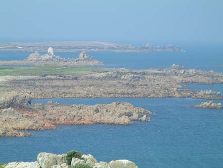
Overview: The name 'Scilly' comes from 'Sully' appropriately meaning the Sun Isles. The islands are located 21 miles WSW of Land's End and measure a tiddly 10 by 7 miles. There are about 100 islands and rocks of which only 6 are inhabited. The total land area is a laughable 6.25 sq miles at high tide and the population numbers just 2000, most of whom live in Hugh Town on the largest island, St. Mary's. The islands belong to the Duchy of Cornwall (lucky Charles), although the uninhabited islands are leased to the Isles of Scilly Environmental Trust. The whole area has been designated a 'Special Area of Conservation', so assume that killing and roasting the flora and fauna will be frowned upon. The islands are literally saturated with ancient sites and archaeological remains. Those who believe in pixies and fairies (quite a few Cornish folk) will tell you that the Isles are the last remains of Lyonesse, an Arthurian Kingdom which sank beneath the sea in a cataclysmic storm. Geologists have a somewhat drier explanation; that the islands are an extension to Cornwall which has been slowly drowned by rising sea levels since the last Ice Age, forming a rocky archipelago; imagine Bodmin Moor or Dartmoor with only the craggy summit tors peeking through the water. With beaches.
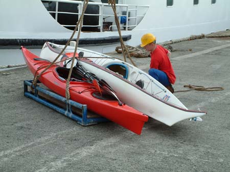
Getting there: Three choices; fly, ferry, or paddle. Taking a plane or helicopter is fast and convenient, however you enter a world of pain regarding cost and you will have to make alternative arrangements for your sea kayaks. There is nowhere yet to hire decent equipment on the Islands. The 'Scillionian III' ferry is how most will reach the islands, a stomach-wrenching three hour crossing from Penzance to St Mary's. They are happy to crane (unloaded) kayaks aboard as cargo if told in advance. The car must be left at Penzance and there are a number of long-stay secure compounds for this purpose; your car will accumulate an impressive array of seagull poo. None of this is cheap; assume around £75 pp for the return ferry trip, plus £44 for your kayak (although for reasons unknown, our second kayak was charged at half-price) and about the same again for a week's parking. The final option is to paddle from Land's End. Anyone capable of that won't need this article.
Accommodation: Wild camping is sadly not permitted, you must stay at and shell out for designated campsites. There is logic in this, as although quiet spots are not hard to find (and I know of groups who have made use of them), they are usually left quiet for sound ecological reasons; before shoving your pegs in, take a close look at the surrounding wildlife and assess your impact. The good news is that the official campsites are pleasant enough, are mostly fairly priced and are near the water, with the exception of that on St. Mary's which is a fifteen minute uphill walk. An option for softies is to hire a cottage or similar and use it as a base for day trips; perfectly practical given the relatively small area involved.
Shopping and Food: St. Mary's has plenty of shops and a supermarket. There are twee 'village stores' on most islands, stocking useful things like gobstoppers and tinned peas; the Tresco store even stocking such luxuries as newspapers. The only cash machine is on St. Mary's but the pubs etc. seem happy to accept plastic. Undoubtedly you'd prefer to spend your evenings boiling lentils in a windy corner of a campsite, but there is no harm in knowing that all of the inhabited islands have warm pubs serving good food.
Communications: Radio 4 and Radio Cornwall are readily available on FM radio, the latter giving regular but quirky Scilly weather updates. Mobile phones (Orange, O2, Vodafone, etc.) seem to work well on a 'line of sight from St. Mary's' sort of basis. The coastguard MRCC is Falmouth (01326) 317575.
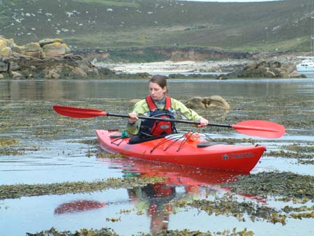
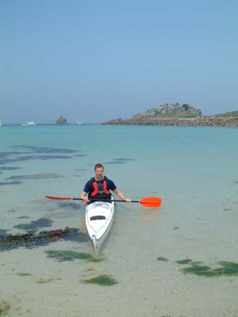
The Paddling: Does your preferred paddling day involve clocking up epic distances in monstrous seas? Chewing on whale blubber to take your mind off the salt water sore where your beard gets caught in your armpits? If so, the Scillies aren't for you. The paddling is mostly characterised by short relatively sheltered hops between islands. Those prepared to take their time and explore the wonderful environs properly will be richly rewarded, those who merely want to clock up mileage are missing the point. You can either spend your days leisurely relocating from island to island, or you can do longer day trips from a single base. The larger islands effectively form a barrier around a central lagoon so there will always be an option of a sheltered paddle, whatever the weather. The inner rim of the lagoon has many amazing beaches, the outer edge has cliffs, reefs and rugged islands. Paddling on the outer sides of the islands, you are exposed to the full force of the Atlantic swells. Tides are not notably strong among the islands, but on the fringes the flows reach up to 2 knots at springs. The inter-tidal zone is vast; in plain English, huge areas of sand and rock dry out at low tide. This is worth bearing in mind, as channels between islands disappear (don't believe that OS map!) and many trips are more sheltered at low tide when reefs shut out the Atlantic swells. Many expert sea kayakers have sworn adoration for paddling in the Scillies, but the region is perhaps most unusual in that mixed club groups or novice sea kayakers can have a great time, under appropriate guidance.
The Islands:
St. Mary's: The largest island also has Hugh Town, the only town. After disembarking from the ferry, many paddlers opt to launch straight away and paddle to other islands; the alternative is to stow the boats somewhere and then slog up the hill to the expensive campsite. If you plan on going there from the ferry, get your luggage labelled for the St Mary's campsite and it appears at the site ahead of you, due to some unseen logistical magic. Be careful in the harbour; the water is chock full of nippy little inter-island ferries, and they don't take prisoners. A circuit of the island is a good day trip however, and leaves the tourist hordes behind quickly. There are a number of impressive burial mounds and chambers worth hopping ashore for on the way around.
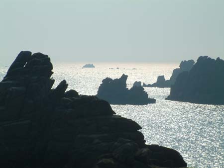
St. Martins: There is a good campsite right on the beach, a first stopping point for many paddlers leaving St. Mary's. The 'Seven Stones' pub and a scrumptious bakery cater to all your needs. To the east are the Eastern Isles, a small group of wild islets occupied by numerous seals. On the isle of Norrour, search for a 2500 year old village uncovered by sea erosion in the '60s, and the remains of a former Penzance ferry which tried to take a short cut. To the west of St. Martins are more uninhabited islands, with two particularly impressive rocks; Round Island, with its sheer sides and lighthouse, and the incredible Men-a-vaur, three towering stacks gleaming white with seagull polish.
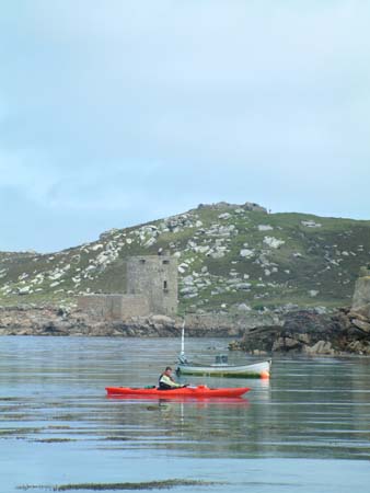
Tresco: There is nowhere else remotely like this in the UK. The northern tip is craggy moorland, with two castles worth a peek. The east is flanked by wonderful beaches which seem to have been wrested from the Tropics, and the west faces the island of Bryher across a narrow sound. Tresco is famous for its Abbey Gardens, created in the nineteenth century to take advantage of the warm local climate. Described as 'Kew Gardens with the lid off', over 3000 species of weird and wonderful plant literally assault your eyeballs. Pay the excruciating £8.50 entrance fee and go see. Food at the pleasant New Inn.
Bryher: Perhaps the bleakest of the inhabited islands, you could be forgiven for thinking you'd just arrived in the Hebrides. The campsite is a short walk from the water's edge and there is a pub-cum-café, 'Fraggle Rock'. The northern tip of Bryher is Shipman Head, actually a separate island. Rounding this brings you into Hell Bay, where jagged rocks meet the southwest swells head-on. To the west are the Norrard Rocks, giving the impression of a mountain range with just the peaks showing…well worth exploring. South of Bryher is Samson, recognisable by its two facing hills. This now empty island has many sad remains of past communities; in the nineteenth century everybody got hungry and left.
St. Agnes: Easily recognisable by the disused white lighthouse on the highest point. Whilst being close to St. Mary's, St. Agnes is arguably the remotest of the inhabited islands; it faces the open Atlantic and reaching it involves crossing a strong tidal stream. The campsite is beside the water's edge on the western side, a gorgeous location overlooking Annet and the Western Rocks. The coast is a mix of sandy bays and granite stacks, quite unforgettable. St. Agnes is connected at low tide to Gugh, a (barely) inhabited island with similar scenery. The pub is the 'Turk's Head'; arrive early for food as every evening, a boatload of Hoorays arrive to quadruple the local population and to clog up the bar infuriatingly, before embarking back to their hotels in Hugh Town.
Annet and the Western Rocks: Annet is only a short distance from St. Agnes, making for an exposed circuit along with the unsettlingly named Hellweathers Rocks. You will have to be prepared to stay in your boat for the duration though. Landing is not permitted as every inch of the island is occupied by nesting birds. Even from the water you can see every kind of squawking and flapping creature, including Puffins which are becoming rare in the Scillies. Seals abound also. The Western Rocks extend out into the Atlantic in a series of reefs, culminating in the towering Bishop Rock lighthouse. If you reach the tiny rock of Rosevear, spare a thought for the men who lived on it for six years in the 1850s whilst building the lighthouse. Although the distances are not big, tides are strong and the commitment is total; experts only and pick your day carefully. The sea around the Western Rocks is littered with wrecks, most notably four ships of the British Fleet who sank there in 1707 with 2000 deaths. When a sailor had suggested to the Fleet Admiral that the Fleet was on course to hit the Scillies, he'd been instantly hung for mutiny. Oops. In a satisfying bit of irony, the Admiral survived the disaster to crawl ashore on St. Mary's. Where a local woman promptly strangled him for his jewellery.
 |
 |
Websites:
http://www.islesofscilly-travel.co.uk/
http://www.scillyonline.co.uk
http://www.rosevear.demon.co.uk/
http://www.ukriversguidebook.co.uk
> reports
http://www.pzcc.net/nikki/Home%20page.htm
http://community.webshots.com/album/70392031BFVgsN
Maps and Books:
All available from http://www.amazon.co.uk:
Ordnance Survey 1:25000 Explorer 101 - best map of the Isles available.
Admiralty Leisure 1:25000 Small Craft Chart 34 - indispensable for tidal advice.
Isles of Scilly Pilot, published by Imray - for the compleat beardie.
Walking in the Isles of Scilly, published by Cicerone - actually a useful
pocket guide to the area.
Scilly's Wildlife Heritage/ Scilly's Archaeological Heritage/ Scilly's Building
Heritage, published by Cornwall County Council - three excellent pocket guides
to everything that moves or doesn't in the Scillies.
Mark Rainsley.
~ ~ ~