| NAVIGATION BOARD FOR CHARTS OR MAPS By Julian Patrick - 2006
I am in serious danger of becoming a "proper sea kayaker" but here goes (no beard as yet)... I used to have "laminated A4 under deck lines".... but there are a few issues with it... 1. If you want a deck bag then the deck space becomes
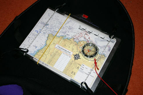
unavailable. I like a deck bag (I know some don't have them or like them). In my deck bag I have warm hat, sunglasses, suncream, small water, chinagraph pencils, GPS, camera, allsorts of junk etc. I know some deck bags have bits of elastic on top for a map but have not seen anything that will keep the map there after large waves or anything like "nice and flat" (and still too far away). In November I had a week of paddling with Rod, a mate who had come across from abroad. We paddled almost every day (Anglesey) and had some great paddling (including one day to the Skerries from Holyhead (Rod in a t-shirt and b/aid it was that sunny and calm). Anyway we also spend some time creating a full set of laminated charts each for Anglesey... and I set out to solve the problem of me "having stuff all over the place and losing stuff in big waves". Tip: Get yourself a cheap laminator and create A4 laminated maps/charts. Much better than a map in a map case. Maps in map cases can easily get washed off decks (not so flat) and using a permanent marker on a map case does not work (map moves around inside for one so "note on headland" becomes "mark on car park"... and on my last map case it did not wipe off with acetone...). Use nail varnish remover to wipe off marker from laminated sheets. Maps or charts. I like charts. Why? They have the following... Overfalls are marked. Best to take both. I recently converted to charts for on the water and have an OS map in the third hatch for back up. It is also easy to laminate a bit of chart AND a bit of map for the "deck". Mark the laminated maps with permanent marker before the trip and use a chinagraph pencil for on the water (I have a permanent marker in my buoyancy aid and get away with it at sea (mostly) by wiping the laminated map with my finger). Tip: Use wooden Chinagraphs as the other ones uncurl themselves and fall to bits - you'll know what I mean if you've seen it. Also have three or four handy, they are light and if you have just one it will break (Sod's Law). Anyway I keep my A4 laminated maps on a HARD piece of plastic on my spraydeck. The hard piece of plastic started life as a Staples branded clipboard. The plastic rectangle is held in place by four small clips (sewn on by a neighbour) which are attached to two vertical elastics (very tight) which cannot move left or right due to grroves at top and bottom). The clips also have short pieces of elastic on them to allow for stretching as the spraydeck goes on. I can slide the maps in and out, left or right. Storing twenty or more such maps is not an issue.
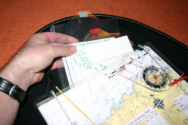
Tucked in behind the maps with coloured tabs (tape) are two rather organised extra info sheets that can be pulled out and slid back as required (anorak like I know but it works)... on here I have "trip planner, overview of key times for the day", "assorted information", "empty scribble pad", "night nav light sequences".
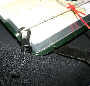
If I get out the boat it just "hangs around" on the spraydeck and is not a problem. However, I have a Karibiner on the b/aid and clip the front of the spraydeck onto it. Have had this on my deck a few times recently, including one session in Penrhyn mawr overfalls where we did some reentry rolls and rescues and wipeouts etc. it's fine and not at all likely to come off. On the pics the yellow line is an elastic band... stops the two extra laminates falling out. Anyway... Rod laughed his socks off as my little system developed (at one stage it did get a bit out of hand and a sccretary sitting on my back deck would not have looked out of place).... but he did say that the final version was rather slick and that could I make him one... Ps. I have good eyesight but I still struggle to see what is happening on that Silva compass up front... Julian Patrick - 2006 (Julian has also devised a cunning crib-sheet to help with factoring the effect of tide into navigation calculations - click here for the article describing the process, which also includes downloadable versions of the relevant docs.) |
~ ~ ~