|
|
|
UNDERSTANDING THE SHIPPING AND INSHORE WATERS FORECASTS The Shipping Forecast and Inshore Waters Forecast both use a standard and abbreviated format to pass a lot of information in a short period of time - by knowing what's being said and in what order (always the same) it's possible to gain an understanding of the conditions, even in poor reception areas if listening to the forecast on marine VHF. The terms used are standardised. As well as marine VHF, weather bulletins for shipping are broadcast daily on BBC Radio 4. The bulletins consist of a gale warning summary, general synopsis, sea-area forecasts and coastal station reports. In addition, gale warnings are broadcast at the first available programme break after receipt. If this does not coincide with a news bulletin, the warning will be repeated after the next news bulletin. Other sources of weather information are linked from the Almanac / Weather page, as is information on MSI schedules for forecasts on Marine VHF. |
| Example Shipping Area Forecast - this is what you'll actually hear during a radio transmission, or read on a text forecast. Click to Listen to the latest forecast on BBC Radio4 (requires sound and an appropriate player) | Explanation (See also "Terms used") |
| THE SHIPPING FORECAST ISSUED BY THE MET OFFICE, ON BEHALF OF THE MARITIME AND COASTGUARD AGENCY, AT 1725 ON SATURDAY 02 JULY 2005 | Time & date of the forecast. |
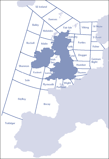
| THERE ARE WARNINGS OF GALES IN SHANNON ROCKALL MALIN HEBRIDES BAILEY FAIR ISLE FAEROES AND SOUTHEAST ICELAND | Any Gale Warnings are issued first, with details of the Sea Areas to which they apply. See the Sea Areas chart below. |
| THE GENERAL SYNOPSIS AT 1300 LOW JUST WEST OF ROCKALL 987 EXPECTED BAILEY 983 BY 1300 TOMORROW |
This is a general overview - at 1300 there is a low pressure area to the west of Rockall - with a barometric pressure of 987. It's expected to move NE to Bailey with a barometric pressure of 983 by 1300 Sunday 3 July. (Low pressure tends to produce unsettle, poor weather - as I write this, it is!). The difference between the pressures is of interest - in this case, the relative similarity tells us that the conditions won't change much. |
| THE AREA FORECASTS FOR THE NEXT 24 HOURS | (Area forecasts run clockwise.) - See the Sea Areas chart below. This is the detail of the forecast relevant to the areas mentioned in the forecast. |
| VIKING NORTH UTSIRE SOUTH UTSIRE SOUTHEAST 4 OR 5 INCREASING 6 OR 7 VEERING SOUTH 4 OR 5 LATER. OCCASIONAL RAIN. GOOD WITH FOG PATCHES BECOMING MODERATE OR POOR |
For the sea areas Viking, North Utsire and South Utsire. These are located NE of UK. Wind from the Southeast, windspeed Beaufort force 4 or 5, increasing to force 6 or 7, veering / changing in a clockwise direction to the South, force 4 or 5 but not within the next 12 hours. Occasional rain. Visibility will be good / more than 5 nautical miles, but with patches of fog and becoming moderate / between 2 and 5 nautical miles or poor / between 1,000 metres and 2 nautical miles. |
| Example Inshore Waters Forecast - this is what you'll actually hear during a radio transmission, or read on a text forecast. | Explanation (See also "Terms used") |
| Issued by the Met Office at 0500 UTC on Friday 19 August. Inshore Waters
Forecast to 12 miles offshore from 0500 UTC to 0500 UTC. |
Time & date of the forecast, and period of validity. |
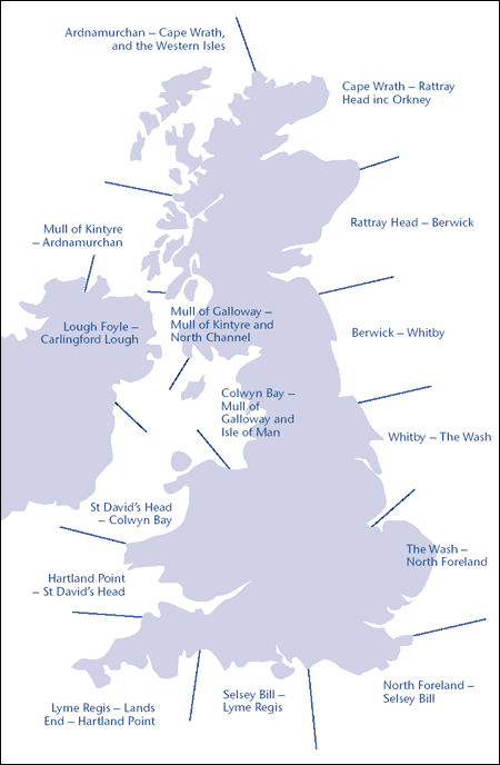
| From Cape Wrath to Rattray Head including Orkney. | The MSI will cover the Inshore Waters relevant to the Coastguard Station broadcasting the forecast. The web based forecasts let you see all the Inshore Waters areas. |
| 24 hour forecast: Wind: westerly 3 or 4 becoming variable 3, becoming northwest 4 near Rattray head by tomorrow morning. |
A bit easier to understand than the Shipping Forecast, the Inshore Waters forecast always says what the information relates to. In this case, the wind is coming from the West, windspeed Beaufort force 3 or 4 but likely to vary. In the area near Rattrray Head it'll become Northwest 4 by tomorrow morning. |
| Weather: occasional rain or showers, mainly in the east. | It'll rain a bit in the East. |
| Visibility: moderate or good, occasionally poor in the east, with fog patches later in the Moray Firth. |
Visibility will be moderate / between 2 and 5 nautical miles or good / more than 5 nautical miles, but with patches of fog, and poor / between 1,000 metres and 2 nautical miles in the Moray Firth area. |
| Sea State: smooth or slight, increasing moderate or rough between Cape Wrath and Orkney, and near Rattray Head. | (As described - see the Beaufort Scale for more detail) |
| Outlook for the following 24 hours: Wind: north or northwest 3 or 4, becoming variable 2 or 3 for a time then south 3 or 4 overnight. Weather: patchy rain in east, and later near Cape Wrath. Visibility: moderate or good, occasionally poor in the east at first with fog patches. Sea State: slight or moderate, occasionally rough at first along the north coast. |
The forecast then gives the outlook for the following 24 hours, using the same format. |
| Term used |
Definition |
| Gale Warnings |
|
| Gale |
Winds of at least Beaufort Scale
force 8 (34-40 knots) or gusts reaching 43-51 knots |
| Severe gale |
Winds of force 9 (41-47 knots) or gusts reaching 52-60 knots |
| Storm |
Winds of force 10 (48-55 knots) or gusts reaching 61-68 knots |
| Violent storm |
Winds of force 11 (56-63 knots) or gusts of 69 knots or more |
| Hurricane force |
Winds of force 12 (64 knots or more) Note: The term used is 'hurricane force'; the term 'hurricane' on its own means a true tropical cyclone, not experienced in British waters. |
| Timescales |
|
| Imminent |
Expected within six hours of time of issue |
| Soon |
Expected within six to 12 hours of time of issue |
| Later |
Expected more than 12 hours from time of issue |
| Visibility | |
| Fog | Visibility less than 1,000 metres |
| Poor | Visibility between 1,000 metres and 2 nautical miles |
| Moderate | Visibility between 2 and 5 nautical miles |
| Good | Visibility more than 5 nautical miles |
| Movement of pressure systems | |
| Slowly | Moving at less than 15 knots |
| Steadily | Moving at 15 to 25 knots |
| Rather Quickly | Moving at 25 to 35 knots |
| Rapidly | Moving at 35 to 45 knots |
| Very Rapidly | Moving at more than 45 knots |
| Pressure tendency in station reports | |
| Rising (or falling) slowly | Pressure change of 0.1 to 1.5 hPa in the preceding three hours |
| Rising (or falling) | Pressure change of 1.6 to 3.5 hPa in the preceding three hours |
| Rising (or falling) quickly | Pressure change of 3.6 to 6.0 hPa in the preceding three hours |
| Rising (or falling) v. rapidly | Pressure change of more than 6.0 hPa in the preceding three hours
|
| Now rising (or falling) | Pressure has been falling (rising) or steady in the preceding three hours, but at the time of observation was definitely rising (falling) Note: For those more familiar with the millibar, 1 hPa = 1 mb |
| Wind | |
| Wind direction |
Indicates the direction from which the wind is blowing - see
this Factsheet
on understanding wind direction. |
| Becoming cyclonic |
Indicates that there will be considerable change in wind direction
across the path of a depression within the forecast area |
| Veering |
The changing of the wind direction clockwise, e.g. SW to W |
| Backing |
The changing of the wind in the opposite direction to veering (anticlockwise), e.g. SE to NE |
| Sea State | |
| Smooth | Wave height less than 0.5 m |
| Slight | Wave height of 0.5 to 1.25 m |
| Moderate | Wave height of 1.25 to 2.5 m |
| Rough | Wave height of 2.5 to 4.0 m |
| Very rough | Wave height of 4.0 to 6.0 m |
| High | Wave height of 6.0 to 9.0 m |
| Very high | Wave height of 9.0 to 14.0 m |
| Phenomenal | Wave height more than 14.0 m |
UK Shipping Forecast Areas (Map image from Met Office)
Uk Inshore Waters Forecast Areas (Map image from Met Office)